 |
|||||||||||||||||||||||
|
|||||||||||||||||||||||
| First page | Financiers | Contact |

 |
 |
 |
 |
 |
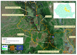
The project’s implementation area is overlapping the Central and South Eastern surface of the Eastern Carpathians, remarkable by the presence of favorable habitats for large carnivores, which comprehends the core of maximal concentration in Romania of Ursus arctos population. The region developed generally on the North-West and South-East line, corresponds from administrative point of view with the mountain area of Vrancea, Covasna and Harghita counties. The whole surface of these 3 counties which overlap the project’s site is 1.519.603 hectares (15.196 square km’s). On this surface approximately 550.000 hectares (5500 sq. km’s) are covered by forests and represents bear habitats. |
The project’s implementing area is developed in relation with the central line defined by the community interest sites in which the presence of large carnivores is remarkable. From NW towards SE are successively the Natura 2000 sites: Harghita Madaras, Cheile Varghisului, Herculian, Tinovul Mohos-Sf. Ana Lake, Ciomad-Balvanyos, Oituz-Ojdula, connected at south with the local Network of Large Carnivore Protection of Vrancea County and with the Putna Vrancea, Lacul Negru, Padurea Verde, Cascada Misina, Sindrilita, Poiana Montioru-Ursoaia protected areas. |
VRANCEA Organized on gradually decreasing levels which get smaller in altitude from West towards East, the relief of Vrancea County comprehends: Vrancea Mountains (with the intermountain basins of Gresu and Lepsa), the hill lands and depressions of the sub Carpathian level, the inferior Siret Flatland, edged by the Moldavian Tableland at NE and Ramnicului Lowland at SE. The Vrancea Mountains are curled mountains, formed by peaks born by the fragmentation and erosion of a 1700m platform (Goru-1785 m, Lacauti-1777, Giurgiu-1720 m, Pietrosu-1672 m, Zboina Frumoasa-1657 m) and of another 1300 m high platform (Zboina Neagra-1349 m, Tisaru-1269 m, Frumoasele-1213 m, Lapos-1250 m). The most important sub divisions of Vrancea Mountains are: the western branch, or the alignment of the western peak, the middle ridge, which is aligned on the same direction, at 5-7 km eastern declination, parallel with this on approximately 40 km’s length, and the mountain edge, the most eastern mountain structure of the relief. To all these we must add the Coza Massif (1626 m) individually treated, which lays on the S-Central position. The level of sub Carpathian hills which includes also the meadow area between them and the plateau hill lands, which hold the high western hills, the internal hill rows, the internal depressions and the eastern hill rows which makes the connection with the lowest level of oriental flat lands. The lowest level is represented by the Lunca Siretului and Campia Ramnicului. |
COVASNA At south from Harghita we can found Covasna County, set down at the central part of the Carpathian Curve, on a surface of 3709 sq Km’s. The Harghita Mountains at the N-Western side of the county, with altitude between 520 and 1558 m, occupying around 33900 ha (9% of the county’s surface), show the following subdivisions: the volcanic cone’s level (Cucu, Pilisca, Comadul and Murgul), the level of volcanic plateau, the Bixad-Ozunca depressions. At South we can see the Bodoc Mountains-1240 m, on 40500 ha, and Baraolt -1019 m, on the surface of 44000 ha (12%) which goes down towards the Depression of Brasov. The Nemirei Mountains – 1640 m, with 27600 ha surface, include 3 subunits: Nemirei Mountain, which hold the slopes of Tg Secuiesc, Carpineni and Apa Rosie depressions. Small surfaces of Vrancea and Buzaului Mountains and Brasov Depression occupy the eastern and southern regions of the county. Vrancea county is situated at the South-Eastern side of Romania, at the exterior side of the Carpathian Curve, at the intersection of the 45 degrees northern parallel with the 26 degrees eastern longitude meridian. |
HARGHITA Harghita county is situated in the Central-Western part of the Eastern Carpathians, being the 13th as size in Romania, having a 6639 sq km’s surface, representing 2,8% of the country. The relief’s major ridges are based by the 2 mountain rows: developed on NW and SE directions. In the central part exists the approximately 150 km long volcanic massif ridges: Calimani (2100m)-Gurghiu (1778 m)- Harghita (1800 m); on the eastern part are rowed the christal-mezozoic and flis based massifs: Bistricioarei (1689 m)- Giurgeului (1575 m)- Hasmasului (1792 m)-Ciucului (1490) and Nemirei. The two mountain rows are separated by the depressions of Bilbor, Borsec, Giurgeului, Ciucului and Casinului. In the western part of the volcanic chain the relief, through a huge volcanic high land and a row of sub Carpathian hills comes down until the Podisul Tarnavelor at the SW part of the county, holding a small part of the Transylvanian Depression. The relief presents a big variety of forms and altitudes, between highs over 2000 m’s (the peak of Iezerul Calimanului) and only 400 m (the meadow of Tarnava Mare). |
